More about HKUST
Spatial Trajectory Computing
A spatial trajectory is a trace generated by a moving object in geographical spaces, where a moving object can be any entity whose locations can be continuously captured using location positioning devices or monitored by various types of sensors. With the rapid development of location-positioning and sensor systems, navigational and social network applications, wireless and telecommunication technologies, a myriad of spatial trajectory data has been available representing the mobility of a variety of moving objects, such as people, vehicles, assets, animals, and natural phenomena. Spatial trajectory data is a typical type of big data, featuring extremely large volumes, high level of structure and semantic diversity, and the dynamic and streaming nature of the data and the related environment. They contain rich information to monitor and to discover the relationship for moving objects and locations at an unprecedent scale. Spatial trajectory data management and analytics are fundamental technologies to enable intelligent transport systems, location-based services, resource tracking and scheduling, emergency responses, urban planning, IoT and smart city, to derive values from big spatiotemporal data.
Professor Xiaofang Zhou is a leading researcher in spatial trajectory computing, focusing on the processing, management, retrieving, and mining of trajectory data and their broad applications. His team has adopted a systematic and holistic approach to trajectory data computing for the entire lifecycle of spatiotemporal data. Their work has been extensively supported and adopted by the IT industry and the end-user sector.
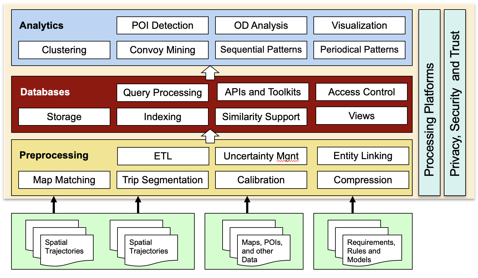
The three key aspects of their work, which form the three pillars of spatial data science, include (1) Spatial Data Quality Management: Data quality is defined as "fitness for use". The notion of good data quality is fundamentally challenged by the fact that trajectory data is typically collected for one purpose (i.e., location monitoring) but later used for many other purposes through data mining and machine learning processes to support a wide range of decision making tasks. Our team has developed a suite of trajectory data quality management approaches from novel map matching and map inference tools to a trajectory data calibration framework that has formally laid the foundation of high quality trajectory analysis. (2) Big Spatiotemporal Data Management System: traditional database management systems and data warehousing systems cannot be used to support trajectory data management and analytics because of their large volume, complex and dynamic nature, unstructuredness and sophisticated and diversified processing requirements. Existing big data technologies also struggle to deal with trajectory data due to the lack of support for spatial and temporal data characteristics. To this end we have developed novel data storage structures, indexing methods and query processing strategies for trajectory data for a number of new computing platforms such as main-memory computers and Map/Reduce-based computing clusters. (3) Advanced Spatiotemporal Data Analytics: database management systems, data warehousing systems and data mining tools can support descriptive analytics (to find the existing facts and patterns in the database), and the advances in machine learning and the marriage of machine models and database systems make it possible to support predicative analytics (to find what might happen in the future, such as future road conditions and whereabouts of objects, expected time of arrival, and possible traffic jam). We view seniors and machine learning models as two new types of data sources we need to manage, one coming from a deployed network of monitoring devices in real-time and another coming from machine learning models that need to be invoked. These new data sources need to be modelled and an optimally selected subset of sensors and machine learning models can be requested based on a given analytics query (i.e., a query is considered as an optimization context). In such a way, we can support descriptive and predicative with one single big data management system. Furthermore, we will have the foundation that can support prescriptive analytics, which aims to deal with optimization and decision making tasks to, for example, avoid predicated traffic accidents, delays and traffic jams.

Our vision is to develop a highly scalable, quality-aware, general purpose, and open system to manage spatiotemporal data, to take advantage of new computing platforms, and to support descriptive, predictive and prescriptive trajectory data analytics, with applications in Intelligent Transport Systems, IOT and Smart City applications.
Navigation

Navigation

 Facebook
 LinkedIn
 Instagram
 YouTube
 Contact Us